


وصف لـ Spyglass
Spyglass is an essential offline GPS app for outdoors and off-road navigation. Packed with tools it serves as binoculars, heads-up display, hi-tech compass with offline maps, gyrocompass, GPS receiver, waypoint tracker, speedometer, altimeter, Sun, Moon and Polaris star finder, gyro horizon, rangefinder, sextant, inclinometer, angular calculator and camera. It saves a custom location, navigates precisely to it later, shows it on maps and using augmented reality displays detailed GPS info, measures distances, sizes, angles, and does a lot more.
IMPORTANT NOTE ON ANDROID RELEASE
One of the best cross-country GPS navigation tools is now available on Android. Most features are implemented, however, some features available on other platforms are to be done. Also, instead of having multiple apps, on Android it is a single free app with a paid unlock of premium features. Be patient and report bugs, if any, directly via our email or the support page.
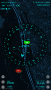
COMPASS & GYROCOMPASS
Accuracy improvement techniques, special compass modes and calibration methods available in Spyglass only make it a real instrument – the most advanced and accurate digital compass.
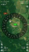
FINDER, TRACKER & AR NAVIGATION
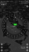
Spyglass operates in 3D and uses augmented reality to show object positions, info and directions to them overlaid over camera or maps.
Save current position, add a point from maps, manually enter location coordinates.
Find the saved place later simply by following directional arrows.
Spyglass tracks your target and shows its info – distance, direction, azimuth, elevation and estimated time of arrival.
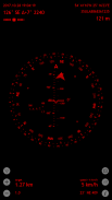
GPS, SPEEDOMETER & ALTIMETER
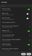
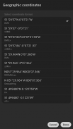
Find and track your location and get detailed GPS data – coordinates in dozens of formats, altitude, course, current, maximum and vertical speed, using imperial, metric, nautical and surveying units.
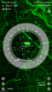
OFFLINE MAPS
See your and targets’ positions on maps using different map styles and alternative map providers – plan waypoints and measure distances. Offline maps optimized for retina displays are available for download.
TRACK POLARIS, SUN AND MOON & NAVIGATE BY STARS
Track positions of Polaris, Sun and Moon with arc second precision – use them as a reference to calibrate compass for maximum accuracy.
OPTICAL RANGEFINDER
Measure distances to objects in real time with a rangefinder reticle similar to sniper sights.
SEXTANT, ANGULAR CALCULATOR AND INCLINOMETER
Find out heights of objects and distances to them – measure visually and calculate dimensions and distances.
CAMERA
Take pictures overlaid with all available GPS, positional and directional data.
DEMO & HELP
Videos:
http://j.mp/spyglass_vids
Manuals:
http://j.mp/spyglass_help
Spyglass هو تطبيق GPS ضروري دون اتصال بالإنترنت في الهواء الطلق والملاحة على الطرق الوعرة. معبأة بالأدوات فهي بمثابة مناظير ، عرض للرؤساء ، بوصلة عالية التقنية مع خرائط غير متصلة ، جيروسكوباس ، جهاز استقبال GPS ، تعقب نقطة الطريق ، عداد السرعة ، مقياس الارتفاع ، جهاز البحث عن الشمس ، القمر ، بولاريس ، الأفق الجيروسكوب ، جهاز قياس المسافة ، السدس ، الميل ، آلة حاسبة الزاوي والكاميرا. فهو يوفر موقعًا مخصصًا ، ويتنقل بشكل دقيق إليه في وقت لاحق ، ويعرضه على الخرائط ويعرض الواقع المعزز معلومات تفصيلية عن نظام تحديد المواقع العالمي ، ومقاييس المسافات ، والأحجام ، والزوايا ، ويفعل الكثير.
ملاحظة هامة عن الافراج عن الروبوت
تتوفر الآن واحدة من أفضل أدوات الملاحة عبر البلاد عبر نظام تحديد المواقع العالمي (Android). يتم تنفيذ معظم الميزات ، ومع ذلك ، فإن بعض الميزات المتاحة على منصات أخرى يتم القيام به. أيضًا ، بدلاً من وجود تطبيقات متعددة ، على نظام التشغيل Android ، فهو تطبيق مجاني واحد يتضمن إلغاء تأمين مدفوع الأجر لميزات متميزة. كن صبورًا وأبلغ عن أية أخطاء ، إن وجدت ، مباشرةً عبر البريد الإلكتروني أو صفحة الدعم.
البوصلة و GYROCOMPASS
تقنيات تحسين الدقة وأوضاع البوصلة الخاصة وأساليب المعايرة المتوفرة في Spyglass تجعلها فقط أداة حقيقية - البوصلة الرقمية الأكثر تقدمًا ودقة.
البحث عن ، تعقب والملاحة AR
تعمل Spyglass في 3D وتستخدم الحقيقة المدمجة لإظهار مواقف الكائن والمعلومات والتوجيهات إليها فوق الكاميرا أو الخرائط.
حفظ الوضع الحالي ، إضافة نقطة من الخرائط ، وإدخال إحداثيات الموقع يدويًا.
ابحث عن المكان المحفوظ لاحقًا ببساطة عن طريق اتباع الأسهم الاتجاهية.
يتتبع Spyglass هدفك ويظهر معلوماته - المسافة والاتجاه والسمت والارتفاع والوقت المقدر للوصول.
GPS و SPEEDOMETER & ALTIMETER
يمكنك البحث عن موقعك وتتبعه والحصول على بيانات مفصلة عن نظام تحديد المواقع العالمي - إحداثيات بالعشرات من التنسيقات والارتفاعات والدورات والسرعة الحالية والسرعة القصوى والعمودية ، باستخدام الوحدات الإمبراطورية والمترية والبحرية والمسحية.
خرائط حاليا
شاهد مواقفك وأهدافك على الخرائط باستخدام أنماط خرائط مختلفة ومقدمي خرائط بديلين - تخطيط نقاط الطريق وقياس المسافات. تتوفر خرائط دون اتصال محسنة لشاشات شبكية العين للتنزيل.
TRACK POLARIS ، الشمس والقمر والملاحة عن طريق النجوم
مواضع مسار Polaris و Sun و Moon بدقة القوس الثانية - استخدمها كمرجع لمعايرة البوصلة للحصول على أقصى درجة من الدقة.
رواية مجددة
قياس المسافات إلى الأشياء في الوقت الحقيقي مع شبكاني rangefinder تشبه مشاهد قناص.
SEXTANT ، آلة حاسبة معملية ومغمورة
تعرف على ارتفاعات الأشياء والمسافات إليها - قم بقياس البصر وحساب الأبعاد والمسافات.
الة تصوير
التقاط صور متراكبة مع جميع البيانات GPS ، الموضعية والاتجاهية المتاحة.
العرض والطلب
أشرطة فيديو:
http://j.mp/spyglass_vids
الأدلة:
http://j.mp/spyglass_help
Spyglass - إصدار 3.9.9
(20-11-2023)

Spyglass - معلومات APK
نُسخة APK: 3.9.9الحزمة: com.happymagenta.spyglassتطبيقات من الفئة نفسها
قد يعجبك أيضًا...


